Movement
The great chalk arable uplands of Norfolk have very little of wild left, being intensively farmed to wheat and barley, rapeseed and sugarbeet. But even here, hedgerows, lanes, and verges have life, and many farms are part of stewardship schemes, leaving ‘weedy’ margins, not cutting hedgerow and lane verges, putting up nestboxes.
The bird I notice most ‘up’ here (up being by Norfolk standards only) is the yellowhammer, singing its ‘little bit of bread and no cheese’ song. (To me, it sounds more like ‘see me see me see me please’.) It’s a bunting (ammer means bunting in Germanic (Saxon?) dialect, so, yellow-ammer = yellow bunting) of dry, open country, and these wide fields suit it well. I am walking, on a warm and sunny day, a section of the Roman road known as the Peddar’s Way, running north from Thetford to Holme. It’s a lane here, bordered on both sides by hedges, with occasional opening s to the fields. A hare lopes toward me: it hasn’t seen me yet. In every spot of shade it stops. Eventually it realizes I’m here, although I’ve stopped and am as still as I can be, and it disappears into the hedge.
-
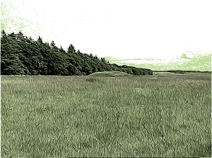
- Bronze Age round barrow near Anmer
The land slopes slowly down, south and west, to the valley of the Babingley. On the highest ground are several Bronze Age barrows, round, slightly conical hills. On the lower slope would have been the fields, and below that, closest to the water, some industry. The barrows were ancient when the Romans – or more likely, auxiliary troops from somewhere in the Empire – built this road nearly two thousand years ago. There is a good chance they were from Pannonia, a Roman province lying south and west of the Danube, based on a military diploma – a document granting citizenship after twenty-five years of service – found in Norfolk a few years ago. Walking away from Pannonia to service in Rome’s most northerly province, they would have heard yellowhammers singing along the road.
***
If I continue south, I will come to the B1145, the old Saxon road running across Norfolk west to east, from the port of King’s Lynn to Aylsham, north of Norwich, where it meets a north-south road. If I walk north, I will come to the road from Flitcham to Docking called the Norman Road. I can find no documentary evidence to tell me this is truly a Norman road, but the name is tantalizing. Roman, Saxon, Norman roads, intersections of time and history.
In the triangle of land bordered by the Peddar’s Way, the Norman Road, and the by-way from Anmer to West Rudham lies another Bronze Age burial mound. This one is reputed to have had a second use: that of the moot-hill for the hundred, the administrative unit of the area in Saxon times. Moot-hills were the location for the courts and administrative debate and rulings and were supposed to be as close to the centre of the hundred as practicable. I walk by it on on a sunny January day, the track beneath my feet muddy and rutted. Did my Saxon ancestors come this way, to hear judgment at this ancient hill, walking in the same mud up from what is now West Newton?
Roads are not static things: they come in to being and they disappear. Sometimes traces remain only as cropmarks seen from aerial photographs and as earthworks on the ground, or even only as excavated archaeology, as is the case with some of the oldest trackways across the fens. Changes in land ownership moved roads; villages were deserted in medieval times by plague or by planned changes by the landowners and roads fell into disuse; enclosure of common lands removed access. But many of the roads shown on old maps of this area are still in use, as bridleways and footpaths. East of Castle Rising the old road from the village to the watermill on the Babingley is now a footpath leading to the bus stop on the A149.
Partridge run from the side of the track; here, they are mostly grey partridge, the native bird, and growing rare in most of Britain. Management practices on the two huge estates bordering the Peddar’s Way here have allowed it to maintain reasonable populations; the same practices allow the yellowhammers to flourish. Harriers – marsh, hen and this winter a vagrant Pallid Harrier – are winter hunters over these upland fields, joined by barn owl and short-eared owl, common and rough-legged buzzard, and little owl. Once, a road, extant on the 1797 map, ran across the Peddar’s Way to the hamlet of Flitcham, where an abbey stood before the dissolutions. No trace of the road, even as footpath or cropmarks, remains west of the Roman road, although it continues in use as a footpath to the east. But were it there, and I could walk it to Flitcham, I would come to Abbey Farm, where the remnants of the fishponds and water management canals of the abbey are now overlooked by a bird hide, and a huge old oak is home to a pair of little owls. These tiny owls – they are about the size of a starling – might have been known to the Roman soldier, but not from here. Nor would my Saxon ancestor have known them (although their first Norman overlords, born in France, might have). Introduced to England in the latter half of the 19th century, they are a bird native to Europe and Asia. It is just possible that my father, as a boy, would have seen them hunting mice over the pastures.