Norfolk, England, May 2015
Beyond the village, west towards the Wash, flat fields of barley and wheat, latticed with ditches, lie on either side of the paved right-of-way out to the water. Once this was marsh, and from the satellite images on Google Earth, the patterns of waterflow can still be seen, like a ghost, or a memory, held in the soil.
Around the village, around its bungalows and houses, shops and pubs, church and hall, people going about their lives shopping, walking dogs, gardening, working, I see other ghosts, memories not my own underlying the quotidian. My father’s memories, and his parents, and beyond that for unknown years. Memories now at their newest eighty-seven years past, and going back for generations.
I would like to know this place intimately, to understand its ecology and geology, its weather, its landscape, its history. I want to watch the seasons here, the ebb and flow of waders on the Wash, feel the wind off the North Sea in the winter, bringing hard frost and snow; hear the nightjars churring on the Fen at a summer’s dusk; see the hordes of geese returning, and leaving, autumn and spring. I would like, as much as can be in a changed world, to know this place as my forebearers did, the knowledge of foot and sight and smell and feel. I have been making small beginnings, over the last thirty years, coming closer together over these last ten. What can I learn, this time, in a month in spring?
I am walking in what I am arbitrarily determining as the boundaries: the old marshes west of the A149; the three commons of Dersingham; the footpath on the old railway line as far north as Ingoldisthorpe; Sandringham Park and Dersingham Bog NNR. The first walk was to and from the Wash.

A century ago my great-grandfather built a tiny wooden bungalow, a beach cottage, on the shingle beyond the marshes. I do not know exactly where. Between Dersingham and the Wash were the marshes, and, the first part of the lane which is now the bridleway from Station Road, which is recorded on Faden’s 1797 map of Norfolk. There was (and is) also the Drift, a droveway to move sheep on and off the marshes.
What lay between the edge of the village and the Wash I imagine to be much like the shooting marsh beside Titchwell: a mix of rush and sedge and ling, cut with hundreds of channels and small ponds, rich with wildfowl, water vole and waders. Perhaps not, though; perhaps it was grazing marsh, diked and drained, wet meadow. And perhaps it was a mix of the two; I suspect this is the most likely. Some of the drains, or sluices, are on Faden’s map, so drainage had begun in at least the 1700s. At some point in the 1920’s, my grandfather, Percy, and one of his brothers-in-law, Sid or Eph, walked out from the Drift to the bungalow, across the wet land and the unbridged waterways. Because this story was still being told eighty years later, I think they arrived very wet, very muddy, and to a good telling off from the women.
Now the bridleway and some of the side lanes are paved, huge, tilting slabs of concrete pavement. I am not sure when this was done: either before the war, when the shingle from the pits at the Wash’s edge was being removed, or after the floods of 1953. To the south of the bridleway, the land belongs to the Sandringham estate; to the north, to (mostly) another landowner. The land is arable, planted to cereals for the most part, but also managed for wildlife, or at least for shooting. Weedy headlands, broad buffer strips on either side of the waterways and around each field, some fields left to grass fallow, strips and clumps of trees: all give shelter not only to the pheasant and red-legged grouse, but to other wildlife. The first morning we walked out there were hares everywhere. Marsh harriers hunted over the fields and the marshes; whitethroat, dunnock, robins, blackcaps, and reed and sedge warblers sang, along with finches, green and gold, and linnets. Songs I do not know, songs to learn, to become part of the tapestry.
A few greylag geese are raising goslings in the fields near the Wash, along with several Egyptian geese. Oystercatchers and ringed plover nest on the beach. Goldfinches twitter from the tops of the blackthorn. Cuckoos call from the woodlands. A whitethroat sings from every bush or tall reed along the ditches, it seems; some will be raising cuckoo chicks, unwittingly.
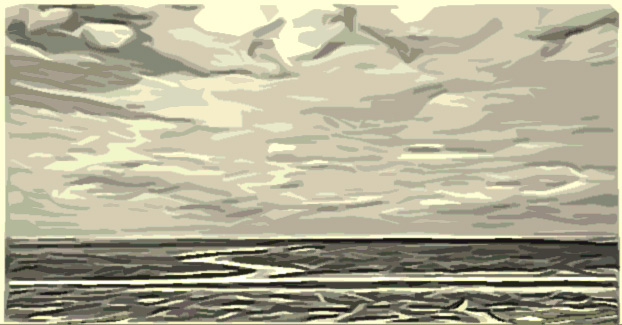
But while the land has changed, two things have not: the sky and the sea. The vast Norfolk skies, the ebb and flow of the tide over Ferrier and Peter Black Sands, and the birds that belong to both: in May, oystercatchers, dunlin, knot and grey plover, feeding at the edge of the sands, moving with the tide, or taking to the skies in huge wheeling flocks, sometimes put up by a peregrine, sometimes by seemingly nothing. And along with waders, black-headed gulls, nesting on the rocks and islands of the pits, or out on the remnants of the shingle gantry, a structure that was built in the 1930s to load the beach pebbles onto boats, and has withstood the storms of 1953 and 2013.
I am drawn to this flat and open land. There are several walks through woodland available to me, but my instinct is to go west, out into the fields, or the fen. I explore different routes: there is a permissive path that runs north from the Station Road bridleway, over to the edge of Ingoldisthorpe Common: I try that. It loops around two fields: the part that parallels the A149 is loud with road noise, and a few birdsongs from the belt of woodland between the road and the fields, but the western side is quiet. I watch buzzards hunting, one coming down repeatedly into the uncut hayfield beside me, but I see no evidence of success. But it’s an adult bird, so it knows what it’s doing. A kestrel hovers over the same grasses but does not dive. In the distance a cuckoo calls, and the ubiquitous wood pigeons beat across the fields.

Another time I access the fields a bit further south, from the Drift. The Drift runs, for much of its length, between a thick hedge or woodland on the south and a ditch on the north, edged first with houses and then with fields. West of the A149 the southern side is a mix of field and woodland, but the boundary is still treed. Good songbird habitat; lots of blue tits, robins, dunnocks. Wildflowers grow on both sides: yellow flag iris in the ditch, kingscup and buttercup, all yellow. On the woods’ side a creeping purple mint – heal all? – and a starry white flower colour the grasses. I need a book. Or an app.
Where the Drift ends at a cross lane – a Sandringham estate farm lane, and at least to the north open to walkers to make a connection with the bridleway to the Wash – I stop, and look west, thinking of my grandfather’s walk. To do that walk today, were it possible, there are at least three waterways to be crossed: Boathouse Creek, a drain, and the River Ingol, challenges in themselves. What is gone is the vast web of minor channels between them, and the right to access.
I watch the fields for a while. Gulls circle and scream at the edge of the Wash, a kilometer or so distant. Pheasants call. To the south, in the woodland called Gogg’s Whins and firmly signed as to no public access, there are feeding stations for the gamebirds: these are birds for the shooting.
A gamekeeper and his black lab begin to walk a field north of me, paralleling the Drift. As I turn and walk east again, we keep pace with each other. When he reaches a small woodland, I hear the shotgun. I can’t determine what he’s after – possibly wood pigeon, more likely one of the Corvidae – crow or magpie. I hear half a dozen shots as I continue east.
Back within the village boundaries a gate opens off the Drift and into a woodland marked on the maps as Bypass Wood. (Unless a woodland or other landscape feature is very old, it will tend to have a practical name: Bypass Wood edges the A149 bypass of the villages of Dersingham, Ingoldisthorpe and Snettisham, and does not appear on the 1992 Ordnance Survey map.) I follow the path round and through the woodland, hearing long-tailed tit, and enter the village fen at its western end. The village fen (once known as Bog Common) is one of the three commons of Dersingham, and would have once been grazed, the reeds gathered and the birches cut for fuel and peasticks; now it is managed as a nature reserve.
I watch a family of robins in one clump of birches, and a single female blackcap. The path branches and I cross the Lynn Road and enter Sandringham Woods, immediately turning left and back up the hill (well, small rise, but this is Norfolk, so it’s a hill), crossing at some point onto Shut-Up Common. More long-tailed tits chatter from the birches which dominate the common now: once it was open heath and bracken, kept that way by the large population of rabbits, and the commoner’s right of wood gathering. Myxomatosis reduced the rabbit population, and most villagers don’t gather wood now. I follow the track across to Heath Road and onto Open Common, and come out on the Lynn Road. From here it’s a ten minute walk back to the cottage.
Had I chosen to walk up Heath Road, I would have passed the house my great-grandfather had built, known then as The Retreat. From this house, it’s a twenty-minute or so walk through Shut-Up Common and across what is now Sandringham Country Park to Sandringham House itself, a walk (or perhaps a boy’s run) my father did frequently in the years he lived here, sent to Sandringham with a message for his grandfather. When he and I and my sister came back, he was in his early 80s and had not made that walk in seventy years, but he unerringly took us across the overgrown common with its branching paths, and onto the estate, the memory of the landscape lying deep within the hidden neural networks of his mind.

One thought on “Reverse Migration: A Discourse into the Spirit of Place. Excerpt One”